Pima Association of Governments creates a variety of interactive maps for use by member jurisdictions and others. All maps are created using geographic information systems (GIS) data for the Tucson metropolitan area. Use the quick links below or scroll down for more information about each map.
- Orthophotos Map
- School Search Map
- Regional and National Alternative Fuels Station Locator Maps
- Tucson Metro Bike Map
- Traffic Counts Map
- Air Quality Monitoring and Information Map
- Resiliency Planning Maps
- 208 Wastewater Reclamation Facility Inventory Map
- Water Accounting Map (Groundwater Assets)
- Travel Reduction Program Web Map
- Regional Active Transportation Plan (RATP) Safety Web Map
- ADOT Road Classification – Web Experience
The Arizona Sun Cloud Data Portal is a repository for transportation and socioeconomic datasets for the Sun Corridor region which includes Cochise, Maricopa, Pima, Pinal, and Santa Cruz counties. PAG works with partners across the megaregion to compile and create datasets for this portal which features the ability to create your own interactive scoring and needs assessments. More than your average database, the Portal incorporates unique equity, broadband, access, safety, environmental, and mobility datasets to help communities of all sizes in the Sun Cloud megaregion make meaningful transportation decisions. Particularly, for small/medium-sized communities with limited staff, the Portal reduces workloads, removes barriers to data/technology, and provides access to rich data. Tools within the portal help streamline needs assessment, generate performance metrics, and aid in prioritizing needs using a customizable set of scoring criteria.
Orthophotos Map and LiDAR
PAG sources orthophotos – aerial photos that are geometrically corrected for uniform scale – of the greater Tucson region for use in planning. They are available to view on the orthophoto map or for purchase in segments approximately one square mile.
To order, view, or utilize PAG’s regional Orthophotography and LiDAR data, please visit the Data page.
School Search Map
This map shows which schools are located near your home address. The School Search Map allows you to view a school’s boundary for attendance and lists the addresses and contact information for elementary, middle and high schools. Public school districts and non-public schools are included in the map.
Regional and National Alternative Fuels Station Locator Maps
Use this map to find alternative fuel stations locally, or throughout the United States. Search by type of fuel and/or address. This map is run by the National Renewable Energy Laboratory, an entity of the U.S. Department of Energy, Office of Energy Efficiency and Renewable Energy.
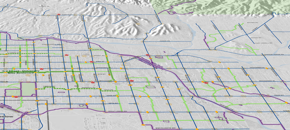
Tucson Metro Bike Map
PAG’s Tucson Metro Bike Map encourages bicycle safety in the greater Tucson region by informing bicyclists of the lower speed, lower traffic volume route options. Highlights for new and veteran bicyclists include enhanced bike routes, bike boulevards and shared-use paths.
Traffic Counts Map
PAG hosts a Traffic Counts Map maintained by MS2, a transportation data analysis company that specializes in traffic count information software. The map uses information collected and distributed by the Arizona Department of Transportation to create a searchable map to research traffic counts throughout the greater Tucson region.
Air Quality Monitoring and Information Map
The Air Quality Monitoring and Information Map shows air quality monitoring stations and boundaries for air quality monitoring areas in the Tucson and Pima County region. Pima Association of Governments is the designated air quality planning agency for the greater Tucson region and works with local, state and federal partners to develop regional air quality plans. Motor vehicle travel, industrial activities, land development patterns and meteorological conditions all affect air quality in the Tucson region.
Resiliency Planning Maps
The Resiliency Planning map set is intended to help demonstrate which locations would benefit the most from increased access to tree shade to reduce heat exposure. This tool can also help identify green infrastructure opportunities for enhanced stormwater management.
208 Wastewater Reclamation Facility Inventory Map
The map shows all wastewater reclamation facilities in the region and their service boundary areas, plus detailed information about treatment systems. Use this guide to help navigate the information available. Learn more about the Areawide Water Quality Management Plan on the PAG 208 Plan webpage.
Water Accounting Map (Groundwater Assets)
This map allows planners to assess subregional impacts and the balance of groundwater recharge versus withdrawal across eastern Pima County and to explore groundwater locations with vulnerabilities and strengths for the community, water providers and the environment.
Arizona Healthcare Assets Map
The Arizona Healthcare Assets Map is a web-based map viewer tool assisting with statewide COVID-19 coordination efforts. The tool includes the location of medical care facilities in the state, contact information and bed capacity, in addition to a vulnerability index based on demographics such as age, income and access to a phone. The tool was developed by Phoenix-based Maricopa Association of Governments, PAG’s partner organization.
Travel Reduction Program Web Map
Understanding your travel reduction options can contribute to a healthier environment for everyone.
Public transit, carpooling, vanpooling, biking and walking are all mobility choices in our region. Check out the interactive map here.