Water quality and water reliability go hand in hand. Strong leadership among water providers, local governments and other stakeholders ensures reliable water for our desert community.
Community interest in preserving and restoring riparian habitats, such as along Cienega Creek, remains strong. While the regulatory structure is in place to ensure that drinking water needs are met, the trade-off has been that groundwater depletion has seriously degraded the flow of natural streams in the region.
Stormwater increasingly is becoming a viable water source. The use of water harvesting systems continues to grow and people learn more about the value of water conservation to sustain resources for future generations.
PAG’s watershed planning reports, including a diverse history of projects, can be found in the PAG online library.
Sign up to be added to PAG’s watershed planning email list to receive water-related news updates and notices for meetings and public events.
Examples of PAG’s water reliability projects:
Cienega Creek and Davidson Canyon Mapping
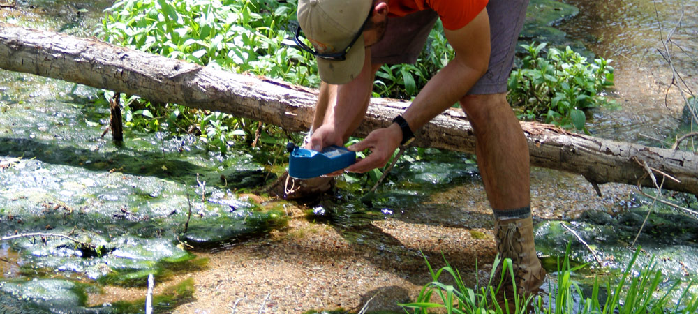
Cienega Creek and Davidson Canyon are both Outstanding Arizona Waters and are among the 18 priority waterbodies identified in PAG’s 208 Plan for protection. PAG conducts quarterly wet/dry mapping of flow reaches and water quality measurements along these waterways, creating one of the longest-term consistent datasets in the state. The data collected serves as an indicator of regional riparian health conditions and drought impacts reported to the county and state. Cienega Creek is of regional importance as one of the few remaining perennial low-elevation streams in our region. It is dependent on shallow groundwater.
- FY 2024-25 Cienega Creek Summary
- FY 2023-24 Cienega Creek Summary
- FY 2022-23 Cienega Creek Summary
- FY 2021-22 Cienega Creek Summary
- FY 2020-21 Cienega Creek Summary
- FY 2019-20 Cienega Creek Summary
- FY 2018-19 Cienega Creek Summary
- Late 2021 Cienega watershed monitoring shows highest flow in two decades
Shallow Groundwater Report
Shallow groundwater areas have water tables that lie less than 50 feet below the ground surface. Because riparian trees and well owners depend on shallow groundwater, they become vulnerable if groundwater levels decline. PAG’s 2012 Shallow Groundwater Report uses Arizona Department of Water resources and PAG’s well data to define these areas and assess water level changes and water use trends. The report recommends increased monitoring and education.
Lower Santa Cruz River Basin Study
The Lower Santa Cruz River Basin Study was a multi-year study, with final reports produced in 2023, that identified where physical water resources may be needed to mitigate supply-demand imbalances in various future scenarios.
The study employed land use, groundwater, climate and surface water models. Strategies were developed, modeled and tested through cost-benefit analysis to improve water reliability for the municipal, industrial, agricultural, cultural and environmental sectors.
PAG’s role in the study was engagement of these diverse sectors across the region and provision of population projections. Led by Pima County and the U.S. Bureau of Reclamation, additional partners included the University of Arizona.
Learn more about the process here: Lower Santa Cruz River Basin Study – Bureau of Reclamation
Read the results here:
- Lower Santa Cruz River Basin Study summary of results
- Lower Santa Cruz River Basin Study Groundwater Analysis
- Science Summary of Climate and Surface Water Modeling
- Technical Memorandum: Hydroclimate Analysis
- CAP’s Supply and Demand Assessment
- Executive Summary
- Final Report
View the geographic data here:
The study has resulted in local entities applying for and receiving funds to pursue the study’s strategies. Stakeholders additionally continue regional coordination for a multi-benefit approach to water reliability projects through the Santa Cruz Watershed Collaborative.
Learn more about current funding opportunities here:
- WaterSMART | Bureau of Reclamation (usbr.gov)
- Water Infrastructure Finance Authority of Arizona (azwifa.gov)
- Water Infrastructure Finance and Innovation Act (WIFIA) | US EPA